Map © Post Office and British Rail (W)
Map © Post Office and British Rail (W)
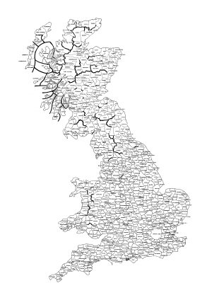
With the introduction in 1958 of Subscriber Trunk Dialling (STD) and the use of timed unit charging, the Post Office introduced the concept of the Charge Group. Exchanges which were geographically close or having a community of interest were placed together in a Charge Group. Calls to exchanges in the same group were local calls. Additionally calls to an adjacent charge group were deemed to be local rate with certain exceptions. The central exchange in a charge group was used as the measuring point to determine the charge for longer distance calls.
Each Group was given a name with some local significance, generally the name of the main town. These names were often used to define the two letter codes used in the original STD codes. Where some natural feature, such as a mountain range or river valley, intervened adjacent groups were regarded as non-local. Such boundaries are shown as heavy lines on the map. This was also true in sparsely populated areas where exchange areas could be large and thus the charge group centres were a considerable distance apart without any reasonably direct routes. Such distinctions were lost with changes to the charging structure introduced in the 1990s.
This version of the map was traced from a Post Office original in the drawing office of British Railways Western Region some time in the late 1970s. The original ink-on-linen transparency has been lost but a few dyeline prints remain and this is a scanned image of one of them in my possession. The original print is on A1 paper and it has been reproduced full-size. However, using the 'Shrink oversized pages to fit paper size' option in Adobe acrobat it can be printed on A4 and is just about readable.
I have started added the STD codes to each area. The second sheet of the map contains the ones added so far.
Repository